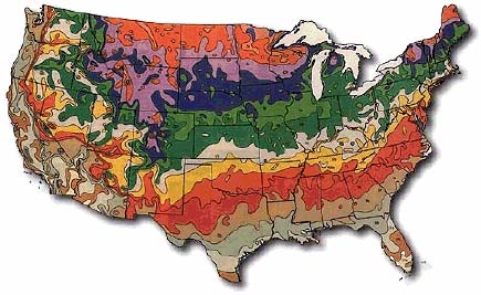
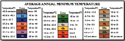
USDA Zone Map and Temperature Chart
I looked and looked for a resource to help our customers determine
their
USDA planting zone. I found a great one someplace (can't remember now)
where you type in your zip code and it told you your zone.
Unfortunately,
when I typed in our zip code the zone it gave was wrong! Oh well. I've
looked at a few different maps and this one seemed to be the one with
the
most detail (like the state border lines, a big help!). Text and
graphics
below are from http://www.bulbsociety.com.
Another source to check out is the National Arboretum's webpage.
Their zone map is hyperlinked for greater detail of each state http://www.usna.usda.gov/Hardzone/ushzmap.html.
The United States Department of Agriculture (U.S.D.A.) has established
Plant Hardiness Zones for the USA, Canada and Mexico based on analysis
of
the range of average annual minimum temperatures experienced in each
area as recorded during the period 1974 through 1986. According to the
U.S.D.A. temperature data book issued by Meteorological Evaluation
Services Co. Inc. of Amityville, NY, "the purpose of this data listing
is to
enable one to determine the hardiness zone of any given city, town or
location used in the map analysis as well as to provide the annual
minimum temperatures over the 10-plus years for comparison with future
weather."
Copyright © 2005 Amity Heritage Roses